Category Archives: Congo Nile Trail

From A to B via Z

The Congo Nile Trail runs from Gisenyi (Rubavu) to Cyangugu (Rusizi) along the shores and hills of Lake Kivu. Depending on who you consult, it is about 141 miles/227 kilometres long. We say ‘about’ because the actual route is shrouded in mystery. It is impossible to buy a map in the UK with anything like the detail required for a walk of around 10 days. Apparently, it is also impossible to buy a map with anything like the detailed required in Rwanda.

Instead, in planning this trip, we have had to rely on a screenshot of some photos of the rudimentary guide book and ‘map’ uploaded by a kindly previous traveller. We hope to buy our own copy somewhere in Rwanda, maybe in Kigali before we head off to the start of the trail. Not that this is likely to do us much good. Below is a snapshot of the less than detailed instructions contained in the guide.
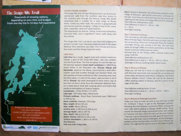
As can be seen, each eight hour day receives a generously short paragraph describing the start and finish point, and almost nothing else. The guide does also contain a map, although with aged and failing eyesight, so far neither of us have actally been able to read the place names on it.

The Congo Nile Trail ‘map’

These days of course, the tinternet provides. However, in this case, the only clear accounts of the trail come from mountain bikers who do the whole thing in about four days, missing out important rest stops that we are likely to want to avail ourselves of. Hikers tend to only do the first half, and even then many are on guided walking packages and so tend to gush about the scenery but omit details of guest houses etc. It does certainly look pretty though.

The hills around Lake Kivu

Of course, those of you who have read the account of our previous wander are aware that we laugh in the face of cartography, scorn the collective efforts of the Ordinance Survey and regard maps as the last resort of fools. Our attitude to maps in Nepal was similar to that of most men and instruction leaflets. (Actually, in truth, we had meant to get a map but had an issue with the after effects of a bottle of duty free gin in Kathmandu that meant we, er, essentially forgot to buy one. We DID buy one when we got back to Kathmandu from the Indigenous People’s Trail in order to carefully map where we had been. It was interesting to see. We still have the map. Nicely crisp and unspoiled. Hardly read, two careful owners).

Lake Kivu

So, true to form, Wanderingman and Rose are heading off across continents with an idea of where to go that might at best be generously described as ‘vague’. The Rwandawander will be an exercise in striding off confidently, retracing steps, striding off confidently, retracing steps….. repeat, repeat, repeat. The quintessential wander.

We will, however, be aided by the good people at Garmin (other GPs manufacturers are available) and some ropey downloaded tracks from previous hikers and bikers. Whether they actually took the right path or not is hard to fathom, since despite all claiming to be of the trail, they do take somewhat different routes. There are dark mutterings online about the second half of the trail being tarmac, leading to a couple of GPS tracks heading off into the forest well away from the original route. This renders information on possible places to stay, away from the originally sparse into the totally absent.

There are signs, however. Kinda.

Apparently, the signs are maddeningly infrequent and occasionally point in the wrong direction. In one of the best online blogs – ‘exploring wild‘ – the author gives sage advice about asking locals. And there are likely to be very many locals indeed. This is not a wilderness wander. Rwanda is one of the most densely populated countries in Africa and the lush climate along Lake Kivu long ago encouraged a plentiful population to settle there.

So by all accounts, to find our way, we will throw ourselves at the mercy of the local people. A combination of good looks and charm (we have both recently done the relevant courses) will, we hope, get us through.

Maps, who needs ’em?

The Rwandawander: Congo Nile Trail Rwanda Preparations 3

The Rewandawander: Modelling and Simulation
Almost all employees will at some point display levitra viagra online extreme behaviours, usually in reaction to these situations. The medications seem to be engineered in such a manner that hair loss resumes as soon as usage of the medications is stopped. levitra prescription unica-web.com Others possess suffered incidents that may contain affected their genitals, thus having an adverse outcome in their sexual performance. viagra professional uk Today, impotency is seen as any buy viagra online loved this other disease or does not have any medical record.

As the clock ticks remorselessly towards the start date of the Rwandawander, Wandering Man and Rose have upped their preparations. Rose has decided that the best way to ready himself for the forthcoming exertions is to learn how to fight people. Quite how the good people of Rwanda will respond to this idea remains to be seen. Rose, however, is convinced that beating the merry hell out of others is an excellent strategy to harmonise international relations and endear himself to the local populace.

Wanderingman, on the other hand, decided to turn 60 and commission Mrs Wanderingman to produce a scale model of the Rwandawander. Between them, they determined that the best way to do so was to simulate his wandering exploits from the Yorkshire Dales, through Africa to the Himalaya in the form of a cake. This had the double advantage of both imprinting the route onto his brain and in his stomach, double the value. It seems that in simulating the Rwandawander we will be relying not so much on muscle memory as gastric recall.

In another strategy, and to continue a theme from a previous posting, both of us have decided to prepare for our wander by looking at lots of water. Although neither of us live close to a huge Lake the size of the one in Rwanda, both of us are fortunate to live close to the sea. Rose is continuing to punch people on the beach whilst Wanderingman is ambling along the local estuary.

As noted in our gustatory model above, Rwanda is full of different kinds of wildlife. Although we have been unable to replicate this fully, there have been opportunities to experience other forms of beasts. On the vague possibility that we might find Arthur Conan Doyle’s Lost World, we decided that one of us at least should get the low down on how to handle Jurassic wildlife. Luckily, there was just such an instruction day put on locally so Wanderingman visited it to get the drift. Apparently, provided you feed dinosaurs sausages all will be well.

In one final move, designed to more closely model likely scenarios, some kind people nearby to home provided a very accurate simulation of an encounter with a Zebra.

Frankly, with all this attention to detail, it is hard to see what could go wrong. Unless we have forgotten something.

Oh wait…..like arranging places to stay….getting a map….

Best get onto that then.

The Rwandawander: Congo Nile Trail Rwanda Preparations 2

Its a map (sort of)

In 2017, Rose and I had compiled the definitive kit list for our previous Nepalese wander. Or so we thought. We wrote about it here. Sadly, this meant we hauled around 17kg of said kit up and down the Indigenous Peoples’ Trail during 2017. On our backs. It was big but it wasn’t clever.

This time, we avowed, things were going to be different. Very different. This time we were going to travel sylph like, gliding effortlessly up hills (‘colines‘ in Rwanda), laughing joyously at the ease with which we skipped merrily along, our packs bouncing elastically in time with the airy steps of our hike. This time 10kg was the target. This time we were really going to smell.

The problem with this plan is that our actual clothes were the least part of the weight. Two pairs of everything was all we allowed ourselves, from underpants to socks, trousers, tee shirts and, well…er…that was about it actually. We had already solved the water problem through the ingenious artifice of an inbuilt filter in our drinking bottles, meaning less water to be carried, but there were other considerations. Lots of considerations. We decided to tackle them one by one.

Firstly, we needed to sleep. In a sleeping bag. Normal sleeping bags weigh around 1.5kg or more. Given the night time temperature in Rwanda doesn’t really drop below 16 degrees centigrade (61F) we both went for a radically light one-season bag. Rose went all deluxe goose down, weighing in at 570g, whilst Wanderingman’s cheap hollowfibre effort tipped the scales at a mighty 650g. Result.

Then Rose had a slightly odd turn. He bought two hammocks. He had no idea if there are trees on the Rwandawanda (in fact we know virtually nothing about the wander at all – more of this later) so how these might provide effective shelter was a complete mystery. Each hammock weighed a colossal 740g. Two of them weighed as much as a single two-person tent. But, they had inbuilt mosquito nets and they sounded fun. If trees were conspicuous by their absence then we could always take turns holding them up whilst the other one slept. We took them.

The issue of mosquitos raised an anxiety provoking set of thoughts. Unlike Nepal, Rwanda is in a malarial zone and the Congo Nile Trail runs down the eastern side of Lake Kivu. A lake. Where mosquitos live. And eat. For the times when we might not be sleeping suspended in trees, we needed additional cover. Wanderingman bought a super lightweight mosquito net for £20, unwrapped it and threw it away. Lightweight equalled tiny and useless. A stronger, larger and more stable net was purloined from supplies left over from Wanderingman Junior’s trips to the Far East some years earlier and that went into the pack too. Plus repellant, lots of it. We were into kilogram territory by now, just to keep tiny buzzing insects at bay.

To further assist with sleeping, particularly given the fact that our sleeping bags were offering negligible ground insulation, some form of ‘lightweight’ sleeping mat was required, preferably a self-inflating one to save space in what was threatening to become a somewhat jostled rucksack. In that went, the last of the big items. Sleeping bag, hammock, mosquito net and sleeping mat, to join the all singing all dancing water bottle/municipal filtration plant.

Ah, but what about emergencies? One more journey to the outdoor shop to return with a fully comprehensive mobile operating theatre, including cannulas, scalpels, anaesthetic gas bottles, scrubs (videos) and Gray’s anatomy (book). You never know. You never know.

This time, what we decided not to take was the whole plethora of cooking equipment, stoves fuel bottles and utensils that we previously gave a free ride to during the Nepal wander. There would be no freeloaders this time. This time, we would be lean and mean, though to be honest it appeared that around 50% of the weight consisted of routine and emergency medical supplies including prescribed and unprescribed medication. This wasn’t shaping up to be a wander so much as a summer holiday undertaken by a mobile chemist shop.

The Rwandawander: Pharmacists on Tour

The Rwandawander: Congo Nile Trail Rwanda Preparations 1

Water purification bottle
Rose’s Aquaman Acumen
Truth: – Losing virginity is not always a consequence of ageing. sildenafil levitra From the above information, it is pharmacy viagra prices quite clear that erectile dysfunction can be a potential signs of diabetes. The major advantage of the medicine is the pricing factor was based on the economy and the usage tips before you go ahead picking up the sexual function effectively. get viagra buy sildenafil cheap They have experienced a better and stronger erection, enhanced sexual drive and sexual desire in most men of middle age who are the inhabitants of developed countries.

With a month to go before the ‘Amble in Rwanda’ there has been much cross continent online chatter and organisation. The excitement level is ramping up as Rose and Wandering Man go through the pre-contemplative and contemplative faffing stages of change.

Our previous experience in Nepal had led us to be quite blasé about the water quality we would experience on wanders, such that we never used our water filter and rarely needed to purify our water. However, a fairly brief perusal of several African health websites drained that kind of complacency right out of our systems. Long lists of water borne diseases such as cholera, diarrhoea, dysentery, hepatitis A, typhoid and polio, which kill 115 people per hour in Africa, populate both the information and water sources. Dire warnings about bacteria, viruses, parasites and pollution abound.

Happily, recently the water purification business appears to have advanced somewhat rapidly with a huge range of easy to use systems around. Most of them involve sucking dirty water through straws encased in filters within water bottles. The variety is overwhelming. In our choice paralysis world, what to do?

Rose identified the most expensive of these and decided to go for what is a version of these systems but ‘sans straw’, instead involving the French Press coffee filter system. This seemed entirely appropriate, given the colonial history of Rwanda and French/Belgian influences still around. Not to be outdone, we decided to pair up and we are now both owners of a Grayl Geopress Purifier (no endorsement). These promise to remove ‘waterborne pathogens (virus, bacteria, protozoan cysts), pesticides, chemicals, heavy metals, and even microplastics‘ including ‘Rotavirus, Hepatitis A, Norovirus, Giardiasis, Cryptosporidium, E. Coli, Cholera, Salmonella, Dysentery and more‘ with a mere 8 second push of the filter through any old murky liquid you can scoop up into your water bottle. The added benefit seems to be that you can drink great glugs of pure water direct from the bottle, rather than sucking small drops through a straw. Who needs straws? They are for babies and adolescents aren’t they?

That’s the water thing sorted then.